BS 5930:2015+A1:2020 and Eurocode 7 (BS EN 1997-2:2007) establish the framework for ground investigation in the UK, and nowhere along the south coast is adherence more critical than in Bournemouth. The town sits on a geological mosaic of Eocene sands, silts, and gravels where bearing capacity can shift dramatically over short distances. A properly executed SPT campaign delivers the N-value data engineers need to design foundations that account for variable density layers and the perched water tables common across the Bournemouth cliffs and chines. Our laboratory operates under ISO 17025 accreditation, and every SPT rig is calibrated to the energy efficiency ratios required by BS EN ISO 22476-3, ensuring the blow counts you receive are directly comparable with published correlations for settlement prediction and liquefaction assessment where needed.
N-values from Bournemouth's Bagshot Beds can swing from single digits to refusal within a single borehole – skip the SPT and you are designing on assumptions, not data.
Service characteristics in Bournemouth
Typical technical challenges in Bournemouth
Bournemouth's population has grown beyond 197,000, and the pressure to develop on marginal plots – former heathland, infilled chines, and the slopes above the seafront – has never been greater. A single SPT borehole costs a fraction of the structural remediation required when a foundation underperforms because the ground was never properly characterised. The biggest hazard in the Bournemouth area is differential settlement: a strip footing bearing on dense gravel can sit next to a slab founded on loose wind-blown sand, and without SPT data to map that transition, the structure will start cracking within the first few wet-dry cycles. Add the localised risk of collapse in solution features within the Chalk bedrock, encountered at depth across the northern reaches of the borough, and the case for a systematic SPT investigation becomes unarguable. The test also flags the presence of cobbles and boulders within the gravels – refusal on a large flint is useful information that prevents over-designing a pile length.
Our services
Every SPT programme in Bournemouth is supported by complementary services that turn raw blow counts into a complete geotechnical model suitable for foundation design and regulatory approval.
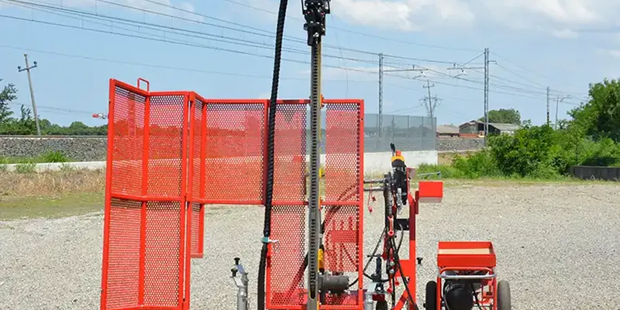
Borehole SPT with Rotary Drilling
Truck-mounted and restricted-access rigs for SPT sampling through Bournemouth's gravels and sands. Each borehole includes lithological logging to BS 5930, groundwater monitoring, and N60 corrections for direct input into bearing capacity and settlement calculations.
Foundation Design Parameter Report
We convert SPT N-values into allowable bearing pressures, modulus of subgrade reaction, and friction angles using established correlations from Stroud, Peck, and the FHWA. Every report includes a discussion of the geological context specific to the Bournemouth area, referencing the BGS 1:50,000 sheet 329.
Common questions
What does an SPT test in Bournemouth typically cost?
For a single borehole with SPT sampling at standard intervals, budgets in the Bournemouth area generally fall between £490 and £680. The final figure depends on access conditions – the narrow lanes and steep gradients in parts of West Cliff and East Cliff can require a smaller rig, which may influence the day rate. A multi-borehole campaign benefits from mobilisation efficiency and is quoted on a per-project basis.
How deep do you need to drill for an SPT on the Bournemouth gravels?
Depth is dictated by the foundation type and the ground conditions encountered. For a typical two-storey residential structure on the Plateau Gravels, boreholes usually extend to 10–15 metres to confirm the gravel thickness and characterise the underlying Branksome Sand. The borehole should continue until N-values consistently exceed 30 for at least three consecutive 1.5 m runs, or until refusal on a competent stratum is demonstrated.
Can the SPT identify the risk of collapse in the Chalk beneath Bournemouth?
The SPT itself is a mechanical index test and does not directly image solution features. However, a sudden drop in N-value within a Chalk sequence, combined with loss of drilling fluid circulation and rod drop, is a strong indicator of a void or softened zone. When these signs appear, the borehole log will flag the anomaly, and we typically recommend follow-up with rotary coring or a geophysical survey to delineate the extent of the feature.
How quickly can you mobilise an SPT rig in Bournemouth?
For projects within the BCP Council area, standard mobilisation is five to seven working days from instruction. We keep rigs stationed in the south-east, so Bournemouth is within our routine operating radius. Urgent investigations for party wall awards or subsidence claims can often be scheduled within three days, subject to rig availability and traffic management requirements on the day.